Gilberts
Climbing up from the Finniss bridge, the line passes through Gilberts, originally built with
both a main line and goods siding. The siding has now been removed, but a small platform on the
eastern side remains and has been used from time to time by SteamRanger to transfer passengers
to local coach tours.
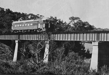
Black Swamp Bridge
The next major bridge on the line, locally referred to as the "Black Swamp" bridge,
crosses Tookayerta Creek, a major stream running into the Finniss and on into the Murray.
Today's bridge is the second to take the rail line over the creek. The first bridge consisted
of wrought iron girders resting on timber piers, supported on red gum piles, but this soon began
to subside into the swampy ground.
Today's bridge, built to the east of the first, has two 61ft spans on concrete piers. In
1884, a windmill, overhead tank and water column were built immediately to the south of the
bridge to provide good quality water to locomotives. The windmill was progressively upgraded to
a hydraulic ram, a boiler and steam pump and, in 1912, by an internal combustion oil engine.
All that remains now are the foundations of the overhead tank.
Currency Creek
The line now run straight for nearly 5kms, crossing the main Goolwa road at the well known
"Canoe Tree" crossing with its flashing warning lights. This was an early SAR stopping
place known as Murtonga. A little further on was the Moonoerp where the parallel
road leaves the line and drops down into the settlement of Currency Creek. Currency Creek was
named after the "Currency Lass" a whaleboat used to explore the Murray in the 1850s. The
"Currency Creek Inn" and a flour mill were built in the river valley. The Inn has recently been
restored as a private residence, but the mill is no more.
The track remains on the high ground to the east as it passes through Currency Creek
station, still fitted with a stock ramp and passing loop (used from time to time to store
maintenance vehicles) and then descends through a cutting onto an impressive bridge towering 23m
above the creek.
As built in 1866, the viaduct consisted of six brick piers and two abutments joined by seven
spans varying in length forom 29ft to 39ft. Over subsequent years various steps were taken to
strengthen the construction, but this was not adequate for Webbs "large steam" locomotives and
in 1926 the piers and abutments were repaired and five 11.9m and two 8.8m spans replaced the
original spans
On to Goolwa
Climbing away through another long cutting the line straightens out and crosses the Willunga and
Middleton roads before commencing to parallel the Strathalbyn road into Goolwa. 3km from Goolwa
the line crosses the road at the site of the SAR's Wirlpana stopping place.
SteamRanger's Goolwa Depot is passed on the eastern side, with points leading to a rail
triangle at both the northern and southern boundaries of the Depot. The Depot is used to
service rolling stock used on the local "Cockle Train" service and as a base for volunteers
living on the south coast.
The line winds its way through the back streets of the town to emerge from a cutting under
the new Hindmarsh Island bridge and into Goolwa yard at the historic Goolwa Wharf
precinct.
|
![[IMAGE]](logos/haebich.gif)


![[IMAGE]](images/maps/yards/currency_yard.jpg)
.jpg)